
The Elizabeth River from the top floor of the Pagoda.
West Freemason
Cobblestone streets, brick sidewalks, historical architecture and iron fencing create a 19th century feel to the West Freemason neighborhood near downtown Norfolk.
Freemason Street got its name from the original Norfolk Masonic lodge located there in the 1700s. In 1776, during the Revolutionary War, the British destroyed over half of the city, including most of Freemason. Afterwards, patriots burned down the remaining buildings as a strategic move. Reconstruction of the original 70-acre neighborhood was not completed until the mid-1800s.
During both of the world wars, large homes in the neighborhood were turned into housing and boarding homes for shipyard, military and defense-related workers.
By the 1950s, many historical homes in the neighborhood had fallen into disrepair and were demolished to make room for parking lots and newer homes.
In the 1960s when a freeway was proposed alongside the neighborhood waterfront, residents fought to keep the area of West Freemason intact and ultimately the proposal was declined.
In 1969, the Freemason neighborhood was submitted to become the West Freemason Historic District. The application indicated that the Freemason District was comprised of 18th, 19th and 20th century homes.
In 1974, a public hearing was held to propose the redevelopment of West Freemason. An attorney representing a railroad conglomerate that owned portions of the Freemason area, attended and indicated his company was interested in redeveloping the property. The meeting resulted in a proposed $100 million phased redevelopment program. The Freemason neighborhood redevelopment was to be the biggest revitalization project in Norfolk’s history. It was to be a classic example of railroad reuse, and revitalization of previously under-utilized and non-taxable waterfront property.
 In 1977, a molasses tank is shown in west Freemason before the large scale redevelopment | NRHA archives
The Virginian Pilot reported in June of 1979 that the Norfolk City Planning Commission had approved the phased redevelopment project. The $100 million project would be primarily residential construction, with renovation of the warehouse and pier along Freemason Harbor. The Oliver T. Carr Company was chosen to construct 94 residential units. Out of the $100 million redevelopment cost, $75 million was to be put up by private developers.
In 1980, the vacant piers and warehouses provided a rare opportunity for revitalization of approximately 25 acres of downtown waterfront property. The Freemason neighborhood consisted of joint public/private residential homes mixed with older rehabilitated homes and new construction in an urban environment. The Boush plant was a major part of this revitalization (see map below).

The Boush plant from a 1928 Sanborn map | Sargeant Memorial Collection
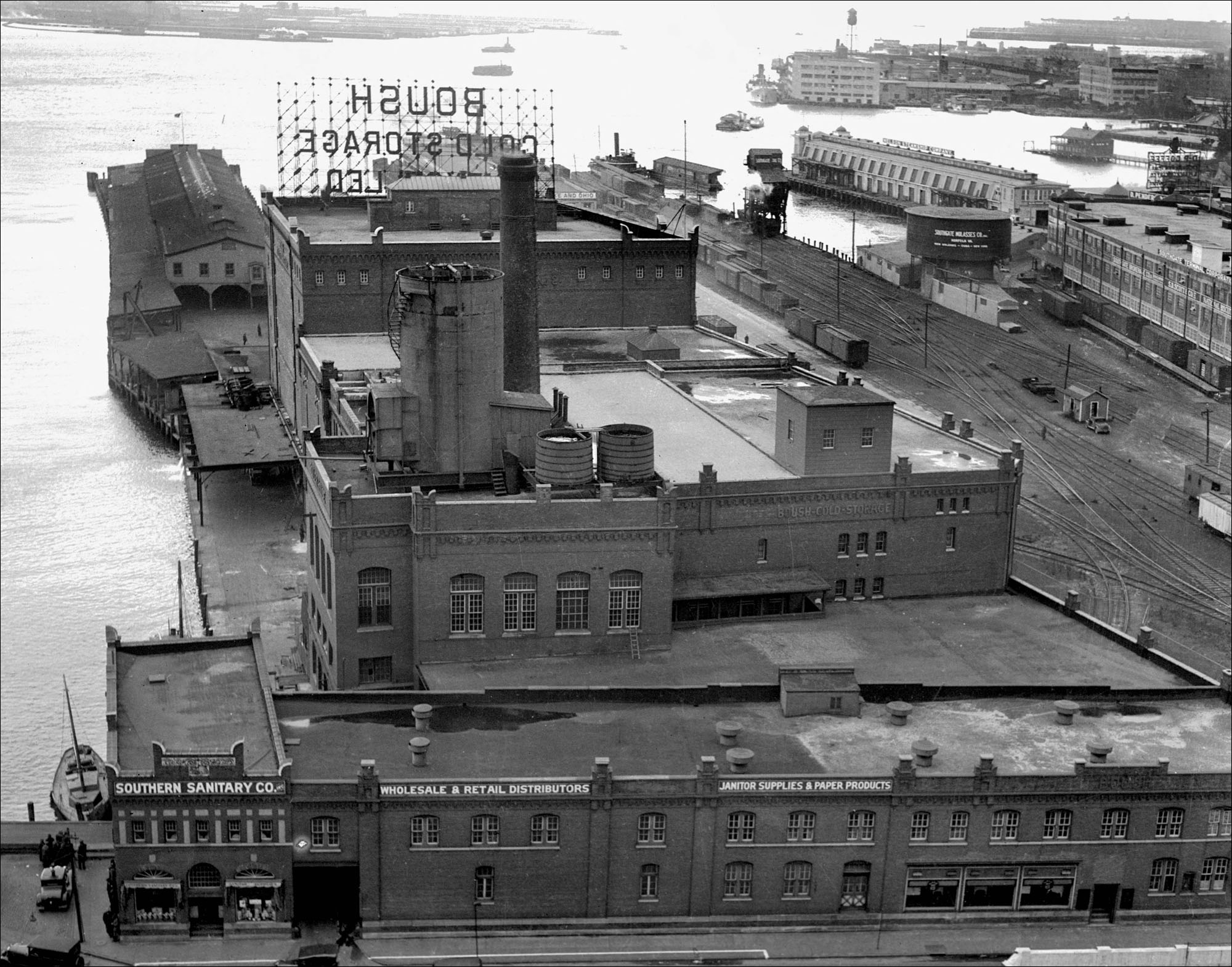
The Boush Ice and Cold Storage Plant in 1931 | Sargeant Memorial Collection
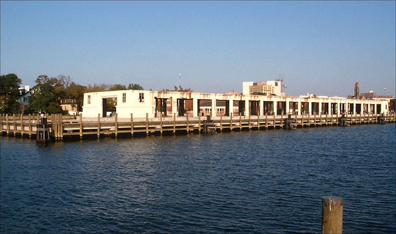
Freemason Harbour Pier shown before the redevelopment in 1983 | NRHA archives
Today, the neighborhood is popular with young, urban professionals and offers a variety of housing, shopping and restaurants. In 2013, the American Planning Association named West Freemason was named as one of ten “great neighborhoods” in America.

Freemason retains the look and feel of the past but is home to a thriving young population.
Freemason Abbey Restaurant is located in the Freemason District three short blocks from the Elizabeth River. The restaurant gets name from the original church as well as the location (Freemason Street). In 1873, the building was constructed for the Second Presbyterian Church. In 1902 the building was sold to the First Church of Christ Scientist, which it served for 46 years. In 1948 the building was sold again and became a meeting location for the International Order of Odd Fellows.
In 1987, the building was sold with hopes of turning it into a restaurant. In 1988, after months of renovations, the restaurant opened for business. Inside the building there are several original features such as ceiling woodwork, windowpanes, stained glass windows as well as the brickwork of the bell tower.
The Pagoda (The Marine Observation Tower) is an Asian-style building and garden located near Freemason Harbor. The octagonal-shaped building was constructed in 1989 upon pillars that once supported a 500,000-gallon molasses tank (see photo above). The Pagoda was a gift from the Taiwan Provincial Government.
Land use changes
North
In the early Sanborn map, along the river off of York Street, a large swath of area is marked “Piles of Sand and Pile of Rock.” That area in a previous map was labeled as Richmond Sand and RS & G Corporation. Just northeast of this area is a site marked “Fire Ruins.” Today, the National Oceanic and Atmospheric Administration (NOAA) occupies the majority of this area.
The early map also shows a few apartments scattered north of York Street as well as the York and Omega Apartments on the south side. The south side also housed a Coast Guard office, U.S. Navy Landing space and the American Red Cross Blood Center.
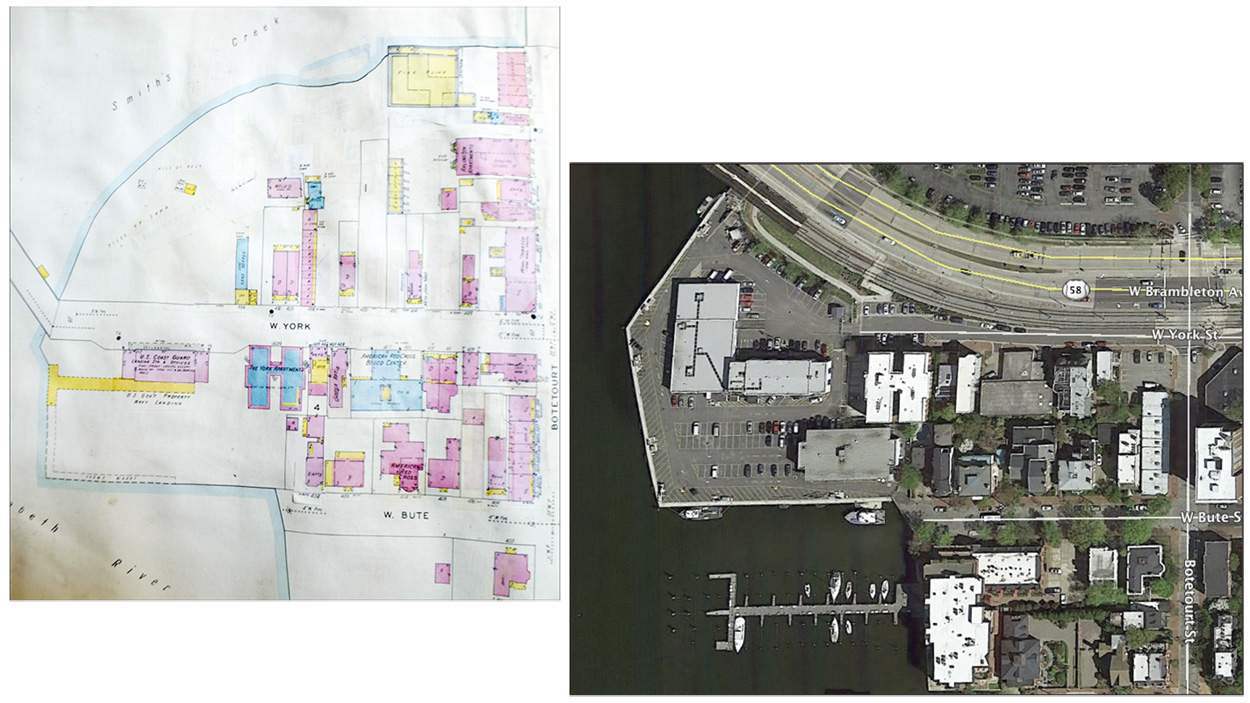
Freemason around York and Bute Streets, 1928-1950 Sanborn maps and 2015.
South
The 1928 Sanborn Fire Insurance maps of the Freemason Street Harbor area show that the area was bound by College Cross (Dunmore Street), West Tazewell, Harbor Square, Botetourt, and College Place Streets. Almost the entire area was owned by the Southgate Terminal Corporation and Chessie System, a railroad company. Today the site is the location of the Freemason Harbour Condominium complex built in the mid 1980s. The entire area has been renovated and is a popular residential area with green space access along the Elizabeth River.

Freemason Harbour area, 1928-1950 Sanborn maps and 2015.
